La Niña : Intro
As autumn deepens, many are beginning to wonder what winter has in store for the United States. After a winter dominated by the warmth of El Niño last year, the meteorological outlook suggests that this year will be different. The Climate Prediction Center has forecasted the development of a weak La Niña, which could shape the winter conditions for much of the United States. This shift in global weather patterns brings both anticipation and concern, especially for regions that depend heavily on snowfall and precipitation during the colder months.
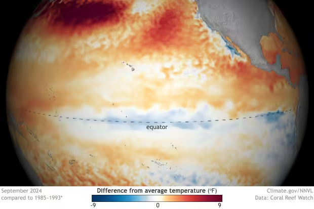
La Niña is a naturally occurring climate phenomenon characterized by cooler-than-average ocean temperatures in the equatorial Pacific. Its impact on weather is most significant during the winter in the Northern Hemisphere, making this upcoming season particularly important for those tracking global climate patterns. While the phenomenon is still in its early stages, its potential effects on temperatures, precipitation, and snow across the country are already being discussed.

In contrast to last year’s warm winter, largely driven by El Niño, La Niña typically brings cooler and wetter conditions to various parts of the U.S. However, La Niña is only one of several factors that can influence winter weather, and its effects can vary significantly depending on the strength of the event.
The Return of La Niña: What We Know So Far
The most recent forecasts from the Climate Prediction Center indicate a 60% chance that La Niña will develop by November. If it does emerge, it will likely persist throughout the winter and into early spring of the following year. A weak La Niña, which is the most likely outcome according to current data, could still play a significant role in shaping the U.S. winter weather.
Unlike the strong El Niño event of last winter, which brought record warmth to the Lower 48 states, La Niña tends to have a cooling effect on the Northern Hemisphere, especially in winter. While the strength of La Niña this year remains uncertain, early forecasts suggest that it will likely remain weak, which could allow other weather phenomena to influence conditions more strongly. According to Emily Becker, an atmospheric scientist at the University of Miami, the weaker the La Niña, the more likely it is that other climate systems will contribute to the overall weather patterns.
The strength of La Niña is a critical factor in determining how consistent its effects will be. A stronger La Niña would likely have a more pronounced and predictable impact, whereas a weaker event might lead to more variability. The coming months will provide more clarity on the strength of this La Niña, but for now, it appears that we are looking at a relatively mild version of the phenomenon.
How La Niña Affects Winter Weather in the U.S.
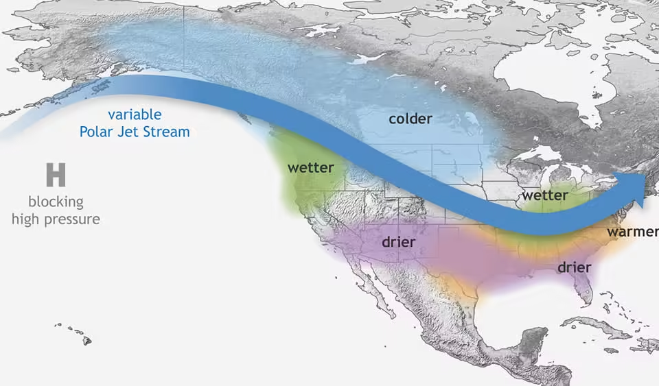
La Niña winters typically share certain characteristics, although no two La Niña events are exactly alike. One of the most notable effects is on the jet stream, which is essentially a high-altitude river of fast-moving air that directs storms across the continent. During La Niña winters, the jet stream often shifts northward, which moves stormy weather away from the southern U.S. and into the northern states.
The most recent winter forecast from the Climate Prediction Center suggests that this winter will follow the typical La Niña pattern. December through February is expected to bring wetter-than-normal conditions to the northern U.S., particularly in the Pacific Northwest, the Midwest, and parts of the interior Northeast. These wetter conditions could be crucial in addressing ongoing drought issues in the Midwest, where dry conditions have been a persistent challenge.

This year’s winter is expected to be a reversal of the pattern seen during last year’s El Niño-dominated winter, which brought wetter conditions to the southern U.S. and drier weather to the North. However, it’s important to note that increased precipitation does not necessarily translate to more snow. For snow to accumulate, temperatures must be cold enough both at the surface and in the upper atmosphere for snow to fall and stick.
Weak La Niña events, such as the one expected this year, often allow for more snowfall in the Northeast. However, stronger La Niña events can limit snowfall in this region because they tend to bring warmer temperatures that push farther up the East Coast. If this year’s La Niña remains weak, as forecasted, there could be more opportunities for snow in the Northeast, but warmer-than-average temperatures across the southern half of the country could temper hopes for a snow-filled winter.
Regional Impacts: What to Expect Across the U.S.
As is the case with most La Niña winters, the impacts of this year’s event will vary significantly depending on the region. According to the Climate Prediction Center, the southern U.S. is expected to experience warmer and drier-than-normal conditions. This could exacerbate drought conditions, particularly in the Southwest, where water resources are already under strain. Southern California, in particular, may continue to face dry weather, which would extend the wildfire season if the region does not receive significant rainfall in the coming months.
Conversely, the northern U.S. could see a much wetter winter. The Pacific Northwest, in particular, is likely to experience cooler-than-average temperatures, which could lead to increased snowfall. This would be especially beneficial for the region’s water supply, as snowpack is critical for both winter tourism and water resources during the warmer months.
In the Midwest, Plains, and Rockies, temperatures are expected to be closer to normal, with some areas potentially seeing cooler-than-average conditions. This, combined with increased precipitation, could lead to a more typical winter for these regions compared to last year’s unusually warm and dry conditions.
Northern California, which typically experiences wetter conditions during La Niña, is forecasted to have near-normal precipitation this year. This is a shift from last winter, which was marked by extreme wetness across much of the state. While La Niña played a role in the heavy rains experienced in California last year, it is unlikely to bring the same level of precipitation this time around. Nonetheless, the state could still see periods of significant rain, particularly in the northern regions.
La Niña and the Global Climate System
La Niña is part of the broader El Niño-Southern Oscillation (ENSO), which alternates between the warmer El Niño phase and the cooler La Niña phase. ENSO influences global weather patterns by altering the sea surface temperatures in the tropical Pacific. During El Niño events, warmer ocean waters drive changes in atmospheric circulation, which in turn affect weather patterns around the world. La Niña, on the other hand, is characterized by cooler ocean temperatures and has the opposite effect on global climate.
These shifts in ocean temperatures affect the location and strength of rising air in the tropics, which ultimately influences the jet stream and storm tracks across the globe. This is why ENSO is such a critical factor in seasonal weather forecasting.
ENSO is highly predictable several months in advance, and forecasters can use changes in sea surface temperatures to develop early projections of potential weather patterns. For example, the cooler ocean temperatures associated with La Niña typically lead to drier and warmer conditions in southern Asia and Australia, while North and South America often experience wetter and stormier weather.
The Impacts of El Niño on the U.S. and Beyond
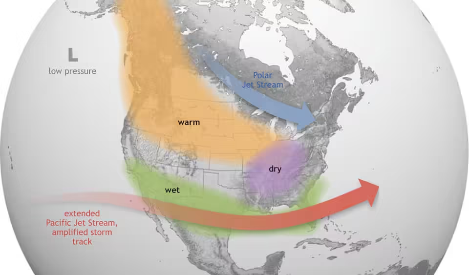
While much of the focus this year is on La Niña, it’s worth taking a moment to reflect on the impact of El Niño, the opposite phase of ENSO, which shaped last year’s winter conditions. El Niño occurs when warmer-than-average ocean temperatures develop in the equatorial Pacific, causing shifts in atmospheric circulation that influence weather patterns worldwide.

During El Niño events, the jet stream over the Pacific strengthens, leading to more frequent and intense storms over the western U.S., particularly in California. The 2022-2023 El Niño event brought record-breaking warmth to the U.S., particularly in the Lower 48 states, and contributed to a winter snow drought in the Northeast and Midwest. This warmth, combined with the overall effects of global warming, resulted in one of the warmest winters on record.
El Niño can also have significant impacts on cyclone seasons around the world. Warmer ocean temperatures in the Pacific lead to more hurricanes and typhoons, while the Atlantic basin typically sees fewer storms because the stronger jet stream prevents hurricanes from developing. This dynamic was observed during the 2015 hurricane season, which saw an unusually high number of storms in the Pacific and a relatively quiet year in the Atlantic.
In addition to its effects on weather, El Niño also impacts the fishing industry, particularly in Latin America. Warmer waters in the eastern Pacific drive cold-water fish away, which can disrupt local economies that depend on fishing.
The Role of Climate Change in Amplifying ENSO Events
As the planet continues to warm due to human-induced climate change, there is growing concern that ENSO events, particularly El Niño, could become more extreme. Recent studies suggest that while the overall frequency of El Niño events is unlikely to increase, the intensity of so-called “super” El Niños could become more common. These more intense events could have far-reaching consequences, including more extreme weather patterns, such as heavier rainfall and flooding in some regions and more severe droughts in others.
Warmer global temperatures mean that the atmosphere can hold more moisture, which could make El Niño-induced flooding even more devastating in the future. This underscores the importance of understanding how climate change might interact with naturally occurring climate phenomena like ENSO.
Conclusion: Preparing for a La Niña Winter
As we approach the winter of 2024-2025, the emergence of La Niña presents both opportunities and challenges. For some regions, the cooler and wetter conditions associated with La Niña could bring much-needed precipitation, while others may face the threat of prolonged drought and wildfire risks. The key to navigating these conditions lies in continued monitoring and forecasting, as well as understanding the broader climate context in which these natural phenomena occur.

While La Niña is only one piece of the puzzle, its potential to shape winter weather across the U.S. makes it a critical factor to watch in the coming months. Whether you’re hoping for snow or bracing for drought, it’s clear that the upcoming winter will be shaped by forces far beyond our control.
More related click here